
The scent of bread drifting from a neighborhood bakery. A mountain lake reflecting snow-covered peaks. Grasslands opening beyond a bend in the road, followed days later by the sunlit remains of an ancient desert city. A journey across Xinjiang unfolds through contrasts, each destination revealing a different relationship between landscape and daily life.
Located in northwestern China, Xinjiang encompasses mountain ranges, desert basins, fertile valleys and historic oasis settlements. The Tianshan Mountains form the broad geographical divide between its northern and southern regions. Connecting Urumqi, Kashgar, Yining and Turpan brings these different worlds into one journey, combining Silk Road heritage with some of the region’s most distinctive natural scenery.
For first-time visitors, the attraction of traveling across northern and southern Xinjiang is the variety—and the connections between places. Snowmelt sustains farmland, mountain valleys guide travel routes, and oasis cities tell the story of communities that developed around water and trade.
Urumqi: Where the journey meets the mountains
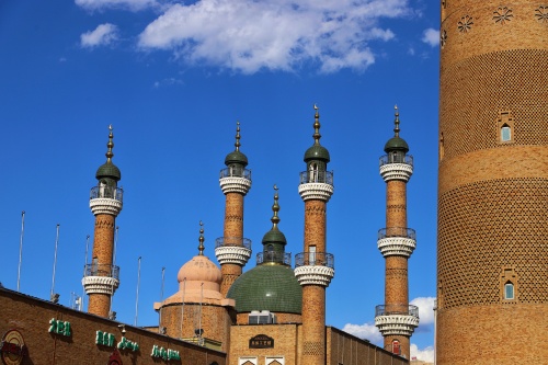
Urumqi, Xinjiang’s regional capital, is a practical starting point for exploring the region. Its transport connections make it an important gateway, while its markets and food offer an introduction to the destinations ahead.
At the Xinjiang International Grand Bazaar, dried fruit, textiles and handicrafts bring together colors and flavors associated with the region. A meal of pilaf, grilled lamb or hand-pulled noodles begins a culinary journey that continues through the markets and restaurants of southern Xinjiang.
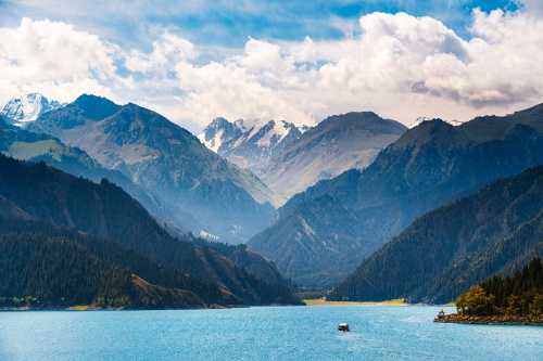
Outside the city, the road toward Heavenly Lake climbs into a different environment. Also known as Tianchi, the lake lies in the Tianshan Mountains beneath the Bogda range, surrounded by conifer forests and mountain slopes. Its setting introduces a greener, cooler side of Xinjiang that can surprise travelers arriving with images of desert landscapes in mind.
A walk beside the water provides time to appreciate the details: forest reflected near the shore, changing cloud over the mountains, and the shifting colors of the lake. It is a fitting beginning to a journey shaped by changes in altitude, climate and scenery.
Kashgar: Following the Silk Road into everyday life
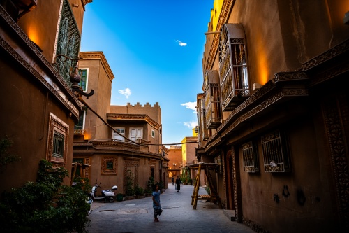
In southern Xinjiang, Kashgar brings the journey into a world of neighborhood lanes, courtyard entrances and busy food stalls. Its position on historic trading routes connecting China and Central Asia has shaped its identity for centuries.
Kashgar Old Town rewards exploration on foot. Carved doorways and narrow streets lead past bakeries, shops and workshops, while small details invite a slower pace. The neighborhood has undergone substantial restoration and redevelopment, and its appeal today combines architectural character with the activity of a living city.
Id Kah Mosque and the Afaq Khoja Mausoleum introduce important aspects of Kashgar’s religious and architectural heritage. Between visits, a pause for tea or a meal offers another way to experience the city. Nang bread, noodles, pilaf and lamb dishes connect sightseeing with the food traditions of local Uyghur communities.
For travelers interested in culture, Kashgar deserves time beyond its principal monuments. Browsing a market, noticing the patterns of a doorway or watching bread emerge from an oven can be as memorable as a formal sightseeing stop. These are shared spaces of daily life, where a respectful approach and permission before photographing people make for better encounters.
Beyond Kashgar: The road to Karakuli Lake
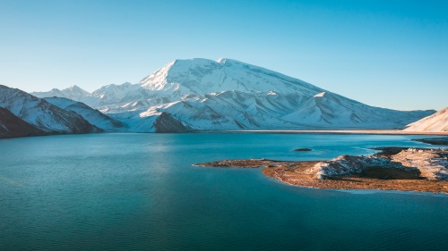
The journey toward Karakuli Lake reveals the mountain landscapes of southern Xinjiang. Following the Karakoram Highway, the road leaves the oasis behind and enters valleys framed by increasingly imposing peaks.
The lake’s setting differs markedly from the wooded slopes around Heavenly Lake. Exposed terrain, open skies and snow-covered mountains create a landscape defined by altitude and scale. In clear conditions, reflections add another dimension to the view, although changing weather is part of the experience.
This excursion involves a long drive and a substantial rise in elevation. Allowing a comfortable pace, carrying warm layers and confirming current access arrangements are important parts of planning the visit.
Yining and the Ili Valley: A journey into green horizons
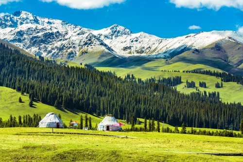
In western Xinjiang, Yining serves as a gateway to the Ili Valley and its surrounding mountain landscapes. Here, farmland and settlements give way to pastures, river valleys and slopes rising toward the Tianshan.
Continuing toward Zhaosu brings a growing sense of space. Around Xiata, the valley draws the eye toward higher mountains, and walking provides a closer appreciation of the landscape. The experience can be adapted to the conditions and the traveler, with the length of an excursion determined by weather, access and walking ability.
Near Tekes, Kalajun Grassland and Kuokesu Grand Canyon reveal the diversity within the Ili region. Kalajun spreads across broad slopes, while Kuokesu introduces steep terrain and winding river scenery. Seen together, they show how mountains and water have shaped a landscape far more varied than the word “grassland” might suggest.
Narat, also commonly spelled Nalati, continues this journey through pasture, wooded hillsides and mountain views. During the warmer months, grazing animals and seasonal herding activity bring movement to the scenery. These are working landscapes as well as places to visit, connected with the livelihoods and traditions of local pastoral communities.
For photographers and nature lovers, time is especially valuable here. A hillside changes under passing cloud, distant peaks appear and disappear, and evening light gives familiar views a different character. Allowing space in the itinerary makes these moments possible.
Turpan: The desert oasis that tells a story of water
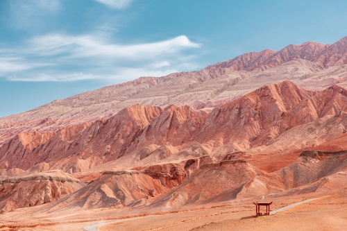
Turpan offers one of the journey’s strongest changes of scene. After mountain lakes and open pastures, its dry basin and earthen ruins reveal how communities adapted to a very different environment.
The Karez irrigation system provides a starting point for understanding the oasis. Underground channels carry water toward cultivated land and settlements while limiting its exposure to evaporation. In a region where water determines what can grow and where people can live, this engineering tradition is central to the landscape.
At Jiaohe, the remains of an ancient city occupy a plateau between river valleys. Weathered streets and structures suggest the scale of a settlement once connected with trade, religion and daily domestic life. Walking through the ruins encourages visitors to imagine the city as a place of activity rather than a distant historical name.
The surrounding area adds further perspectives. Bezeklik’s Buddhist caves reflect the movement of religious traditions along Silk Road routes, while Emin Minaret introduces a different architectural heritage. Grape Valley and Tuyoq reveal the contrast between cultivated ground and the dry hills beyond.
Turpan brings the wider journey into focus. The mountains seen earlier are part of the same geographical story as these vineyards and settlements: landscapes linked through water, movement and human adaptation.
Finding the right season and pace
A journey across northern and southern Xinjiang passes through several climates, so the best departure date depends on the experiences that matter most.
Late spring and summer generally appeal to travelers seeking green grasslands in the Ili region. June and July are popular choices for pasture scenery, although flowering and growing conditions vary with elevation and yearly weather. These months can also bring intense heat to lower-lying destinations, especially Turpan, where outdoor visits benefit from cooler morning hours.
September can offer a useful balance for an itinerary combining mountains and cities. Temperatures begin to ease in southern destinations, while higher grasslands gradually take on autumn tones. Travelers should expect seasonal variation rather than the same appearance throughout the region.
Around 11 to 14 days is a practical planning framework for a first introduction spanning Urumqi, Kashgar, the Ili Valley and Turpan. Flights help bridge the largest distances, while road journeys connect the valleys and scenic areas between regional centers. Additional time allows for more relaxed walking, photography and rest.
The north–south combination particularly suits travelers interested in both culture and scenery. Those with fewer days may find it more rewarding to explore one region in greater depth, leaving another part of Xinjiang for a future visit.
Frequently Asked Questions (FAQ)
What is the difference between northern and southern Xinjiang?
The Tianshan Mountains form the broad geographical divide. Northern Xinjiang is especially associated with alpine lakes, forests and grasslands, while southern Xinjiang is known for oasis cities, Uyghur cultural heritage and historic Silk Road routes. Both offer natural scenery and cultural experiences, which is why combining them creates such a varied journey.
Where should first-time visitors go in Xinjiang?
Urumqi, Kashgar, the Ili Valley and Turpan offer a broad introduction. Urumqi provides access to Heavenly Lake; Kashgar introduces old-town walks and Silk Road heritage; the Ili Valley offers grasslands and mountain scenery; and Turpan brings together ancient settlements and oasis agriculture.
How many days do you need to visit northern and southern Xinjiang?
Around 11 to 14 days is a practical starting point when flights are used for the longest connections. Eleven days allows a focused introduction, while a longer itinerary provides more time for photography, walking and rest. Travelers with less time should consider fewer destinations.
When is the best time to visit Xinjiang?
June and July generally suit travelers seeking green grasslands in the Ili region. September can provide a useful balance between mountain scenery and more comfortable temperatures in southern destinations. The best timing depends on the route, with conditions varying considerably between desert basins and higher elevations.
How do travelers get between northern and southern Xinjiang?
A combination of domestic flights, road transfers and rail travel is usually the most practical approach. Flights connect distant regions, vehicles provide access to grasslands and mountain attractions, and trains link Urumqi with Turpan. Flight availability and seasonal schedules should be confirmed before finalizing the itinerary.
Does an 11-day tour cover all of Xinjiang?
No. An 11-day journey can introduce several major regions, but Xinjiang is too extensive to explore fully in that time. A route through Urumqi, Kashgar, the Ili Valley and Turpan offers considerable variety, while destinations such as Kanas, Hemu, Hotan and Kuqa require additional time or a separate trip.
Experience northern and southern Xinjiang with CITS
The 11-day Xinjiang In-depth Tour of Cultural & Natural Views brings together the landscapes and cultural destinations that make this journey distinctive. Beginning in Urumqi, the itinerary includes Heavenly Lake and Kashgar, an excursion to Karakuli Lake, and travel through Yining, Zhaosu, Tekes and Narat before continuing to Turpan.
Domestic flights connect the more distant regions, while private road transfers link scenic areas and a final train journey returns from Turpan to Urumqi. The itinerary provides a broad introduction to Xinjiang’s contrasts, with opportunities to discuss customization around personal interests and travel dates.
From Kashgar’s neighborhood bakeries to the open pastures of Ili and the ancient waterways of Turpan, each destination adds another perspective. Together, they create a journey through the landscapes that sustained the Silk Road and the communities that give Xinjiang its character today.
Explore the full Xinjiang tour itinerary, or share your preferred dates, pace and interests with CITS to begin planning your journey.